MONDAY, JUNE 19, 2023
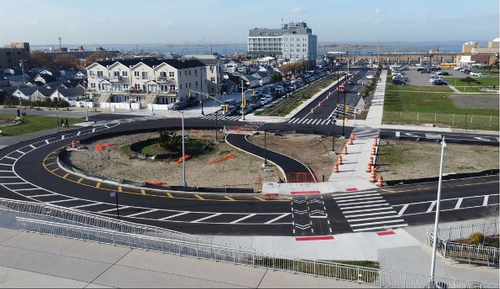
New York City recently announced the completion of its $16.6 million infrastructure project to rebuild Beach 108th Street in Rockaway, Queens, using “porous pavement” to allow rainwater absorption and reduce the risk of flooding.
Redesigns to improve traffic safety, as well as provide better accommodations for pedestrians and cycling traffic stemming from the NYC Ferry landing, were also included in the project.
The announcement was made by the NYC Department of Environmental Protection (DEP), in partnership with Councilmember Joann Ariola and the New York State Office of Resilient Homes and Communities.
Project Details
While the project was reportedly meant to help rebuild an area damaged by Superstorm Sandy, its size had triggered DEP stormwater regulations and required the use of green infrastructure.
As a result, over 1,100 square feet of new permeable concrete was installed along the curb line to allow natural stormwater drainage through the pavement and into the ground. The report states that the porous slabs could absorb up to 1.3 million gallons of stormwater a year and help curb flooding in the city.
|
|
| NYC Environmental Protection |
|
New York City recently announced the completion of its $16.6 million infrastructure project to rebuild Beach 108th Street in Rockaway, Queens, using “porous pavement” to allow rainwater absorption and reduce the risk of flooding. |
The project, which began in March 2021, replaced more than a mile of old concrete curbs, along with adjacent sidewalks. Additionally, over 18,000 square yards of asphalt, similar to porous concrete, was paved over the area.
“This $16.6 million project brings safer streets and innovative new stormwater management techniques such as porous concrete that absorbs water to a coastal area that was greatly affected by Superstorm Sandy,” said NYC Department of Design and Construction Commissioner Thomas Foley.
“DDC is working with DEP and DOT to transform the City’s streetscape in every borough for safety and also resiliency. We will look to expand these methods to other neighborhoods as we manage the greater demands placed on us by climate change.”
Additionally, a new 1,600-foot-long median was installed on the center of Beach 108th Street, along with a two-way, grade-separated bike path, 58 new trees and benches and 20 new angled parking spots for the community.
The new design will also reportedly bring in new, widened sidewalks, crosswalks and curb extensions at crossings and the local bus stop.
“The new Beach 108th Street design brings high-quality, protected bike infrastructure from the boardwalk to the NYC Ferry landing—in addition to expanded pedestrian space and crosswalks. These changes improve safety for all road users and support safe, sustainable, and efficient transportation options for New Yorkers,” said NYC DOT Commissioner Ydanis Rodriguez.
The project reportedly repaired or replaced around 1,100 feet of existing storm sewers, as well as 22 catch basins. Additionally, 140 feet of new storm sewers and three new catch basins were included. About 6,000 feet of old water mains were also reportedly replaced, as well as the addition of two new fire hydrants.
Furthermore, under DEP’s Unified Stormwater Rule, which came into effect in 2022, the use of Green Infrastructure will be required in similar projects across the city.
“By including porous pavement in this reconstruction of Beach 108th Street, we are keeping more than a million gallons of stormwater out of the sewers each year, which will reduce localized flooding and help protect the health of Jamaica Bay,” said NYC Chief Climate Officer and DEP Commissioner Rohit T. Aggarwala.
“DEP’s stormwater regulations require new developments to manage the rain and snow that falls on them with Green Infrastructure, and we’ll be seeing much more of these types of projects in the coming years.”
The project was also made possible by the NYC Department of Transportation, NYC Department of Design and Construction and the Mayor’s Office of Climate and Environmental Justice.
Other NYC Flood Prevention
In 2016, the City of New York embarked upon one of the largest infrastructure projects in the country to help keep the city dry and free of flooding.
The Dryline—also known as the Big U as a nod to the design leaders Bjarke Ingels Group (BIG) in charge of the project—must begin by 2017 and wrap up by 2020, according to the U.S. Department of Housing and Urban Development (HUD) notice that was issued in 2014. The purpose of the project was to help offset potential flooding that the region experienced during Hurricane Sandy in 2012.
The project was run by the Department of Design and Construction of New York and led by engineers AKRF, according to Architect magazine. It has five of the original Big U members: BIG, One Architecture, Starr Whitehouse, James Lima Planning + Development and Arcadis.
Plans included building vertical protection walls planted with a diverse selection of trees, shrubs and perennials; walls that will flip down under FDR Drive when flood events or inclement weather occurs; a series of upland knolls with unique landscapes for recreation that will protect the city’s financial district; and the transformation of the existing Coast Guard building into a maritime museum with a water-facing ground floor that will serve as a “reverse aquarium” so that visitors can observe tidal variations a sea level that will also provide a flood barrier.
Then, in 2020, eight years after Hurricane Sandy battered waterfront communities in the Rockaways and across New York City, officials announced that construction on a $336 million coastal resiliency project was officially kicking off.
Back in 2012, Hurricane Sandy rocked the beaches of New York, damaging or completely destroying more than 1,000 structures on the Rockaway Peninsula, which were reportedly 10 feet high. In addition to damaging the infrastructure, the storm also displaced approximately 1.5 million cubic yards of sand from Rockaway Beach across adjacent communities and/or washed out to sea.
According to reports, the shorefront project involves the construction of six miles of storm surge flood protection along the Queens waterfront. However, the first phase of the project will see the building out and restoration of nearly 20 stone groin structures—similar to rock jetties—into the ocean to prevent additional sand erosion.
The rehabilitation and construction of these flood barriers are expected to provide stabilization for a re-nourished sand beach and dune and maintain the protective beach profile, as well as help to restore local ecosystems and ensure the long-term viability of endangered species.
Following these efforts, crews intended to reinforce a network of dunes with stone and steel sheet pile walls, achieving a height two feet higher than the original structure, and further protecting the coast from wave breaking pressure. The new structures are also slated to limit surge inundation and cross-peninsula flooding.
Additional sand would also be added to this portion of the beach.
Then, in December 2021, New York City officials unveiled the designs for the Financial District-Seaport Climate Resilience Plan as a part of the Lower Manhattan Coastal Resiliency project. Officials estimated that the cost of the proposal is $5 billion to $7 billion and had no set date for completion, but expect it will take 15 to 20 years.
The plan features a two-tiered mile-long waterfront between The Battery and the Brooklyn Bridge with flood walls and gates 15 to 18 feet higher than current waterfront. The lower level will be three to five feet higher than the current walkway. The upper level walkway will potentially host single- or two-story structures like restaurants
The proposal also plans to extend shoreline as far as 200 feet into the East River, with a portion of the new land being utilized for park or plaza space.
Several piers and a heliport will be rebuilt higher than they currently are, including the Whitehall Ferry Terminal, which operates the Staten Island Ferry. Officials are currently unsure of whether they will be able to maintain flood resiliency with the FDR viaduct, a “defining feature of this waterfront,” so the plan can be implemented with or without the bridge.


Construction is planned for new drainage infrastructure, including a pump station. In preserving the East River’s ecosystem, the proposal features ecological preservation strategies like creating a structured habitat and conserving the beach under the Brooklyn Bridge.
Tagged categories: concrete; Department of Transportation (DOT); Environmental Controls; Flood Barrier; Green Infrastructure; impermeable concrete; Infrastructure; permeable concrete; Program/Project Management; Rehabilitation/Repair; Urban Planning